

Featured Photo: Courtesy of Victor Volta
For most backpackers who are fortunate enough to experience the John Muir Trail in California’s Sierra Nevada Mountains, the adventure is a long-time entry on their bucket list. It was a little different for me since it went from idea to action in a matter of months. In late November of 2013, I was visiting Yosemite Valley on a two-day trip. On the first day, after driving through rain and even snow on Big Oak Flat Road to reach the valley, I climbed the Mist Trail under clearing skies to the top of Nevada Fall.
Sitting alongside the trail, bundled against the autumn chill, I rested before the descent. While peeling an orange, I heard the rustling of a squirrel or bird in the manzanita behind me. Turning around to look, I was met with a trail sign for the John Muir Trail, with mileages to various points further on. At the bottom, the mileage to Mount Whitney — 215 miles. I’d been to the top of Mount Whitney twice before as arduous 23-mile day hikes in 2010 and 2012, but I’d never considered trying to reach it via the John Muir Trail. At least not until that day. From that moment, the idea latched on to my brain like a virus and it became an obsession for the next two years.
Just nine months later, I made it slightly more than halfway through the trail before a lower back strain forced me off early. I returned for a rematch the following summer, more experienced and with a lighter pack, and was able to complete a 226-mile adventure in 25 days.
Yosemite National Park
I began on a Thursday morning in mid-July, ahead of the summer crowds — it would take me slightly more than four days (approximately 36 miles) to reach the Yosemite/Ansel Adams Wilderness border at Donohue Pass (elevation 11,056’). The first three days had me traveling generally in a northeast direction before the southern turn at Tuolumne Meadows. Taking those first steps from Happy Isles, the JMT’s traditional starting point, I was filled with unbridled excitement. Anticipating the sights and experiences that awaited me, I was exhilarated at the outset and felt like I could take flight, were it not for the immense pack I had strapped to my back. Photos showed me with a wide smile, clean clothes and reasonably well groomed before I tapped my hiking poles twice for luck, a ritual I’d picked up somewhere along the way, and took those first steps up the trail.
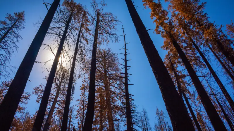
On the morning of Day 2, I came across the fire damaged forest in Little Yosemite Valley that was decimated during the nearly 5,000-acre Meadow Fire the previous September. I’d been expecting it, but it was still emotionally jarring to see. At first, I found the blackened landscape fascinating, with charred skeletons of trees reaching into the sky like black spears and the hopeful signs of new life already springing from the ground along Sunrise Creek. But after more than an hour of walking through the damage, it wore on my spirit, and I was relieved to finally reach healthy forest as the hard climb up Sunrise Mountain began.
On Day 4, heading south, shortly after leaving Tuolumne Meadows, I met a young couple from Santa Cruz, Becky and Todd. I was crouched low, photographing some colorful blooms of groundsel when they passed, and we exchanged hellos. We leapfrogged several times and eventually we chatted a bit longer. Over the next two weeks, we’d see each other almost daily and they became “trail family.” There’s a lot of solitude on the trail and hiking it solo can make it seem lonely — seeing them and others I met along the way lifted my spirits. They pulled ahead for good at Vermilion Valley Resort at about the 92-mile mark, but not before exchanging contact information.
Ansel Adams Wilderness

Upon reaching Donohue Pass at the Yosemite border and taking those first steps into Ansel Adams Wilderness, I was treated to my first expansive view to the distant south, phalanxes of ranges and peaks spread to the horizon like sentinels, seemingly challenging me, beckoning me forward. It was breathtaking and daunting in equal measure.
I spent my 55th birthday (Day 7) intent on reaching Red’s Meadow Resort near Devils Postpile National Monument, where my second resupply package awaited me. It meant a 13.8-mile day, the second longest of the entire trip, although much of it was downhill. But it was well worth it as what awaited me was a transcendent hot shower, hot meals (the non-dehydrated type) at the Mule House Cafe, a fire pit, and a cigar to celebrate.
As I slung my bulging Gregory pack off my torso upon arriving at Red’s, the heavy duty stitching on the top strap gave way. Upon inspection, I realized it would take more than duct tape and prayer to fix. Luckily, it broke when it did. Day 8 would be my first rest day — “zero day” in backpacker parlance.
I took the shuttle into Mammoth Lakes and found a local seamstress with a heavy-duty sewing machine. She obviously did a great job, because seven-and-half years later, the stitch is still holding. Over the course of my stay, I took full advantage of the cafe, cramming as many calories down my gullet as I could before getting back on the trail.
John Muir Wilderness
Among the backpacker community, Vermilion Valley Resort (VVR) on the shore of Lake Thomas Edison* is legendary for its hospitality, great food, and homemade pies. Although I’d had a rest day just days earlier, I didn’t want to miss a chance for another visit after enjoying my 2014 stay so thoroughly. The night of my arrival, I camped in the backpackers’ camp, but for the second night, I splurged for a cabin. It would be my last chance for a hot shower, good food, and a bed until I got to my motel in Lone Pine, east of Mount Whitney, in thirteen days.
The stay surpassed my expectations. The food, shower, and bed were sublime. But what made it special was sitting around the communal fire pit the first night with other campers, while Todd and Becky, who’d arrived that afternoon, played music and sang for us. Both were talented musicians — Todd played the mandolin at home, Becky, the violin and vocals — who performed at various venues occasionally. With Todd on the house guitar and Becky singing, everyone sat, smiling, enjoying the warmth of the fire, the music, and the togetherness under the stars. Finally, after the property generators shut off at 10:00pm, we all started drifting back to our tents, campers, or cabins. It would be the last I’d see of Becky and Todd on the trip, since they’d be back on the trail again the next morning.
The next night by the fire, I had the great fortune of meeting another group that would become my trail family for the rest of the trip. They were a delightful family from Michigan: Michael and Michelle, the parents, and their impressively self-sufficient twelve-year-old daughter, Margaret. As we talked in front of the fire that night, Margaret shared that she’d volunteered to wash dishes in the café and her reward was unlimited milkshakes. Trail nicknames are usually a Pacific Crest Trail tradition, but I told her that from now on, her trail name was “Milkshake,” keeping the family pattern of alliteration intact.
(*The resort is in the Sierra National Forest, not the John Muir Wilderness)
Two days after leaving the comforts of VVR (Day 14), I was less than half a mile from reaching my final resupply at Muir Trail Ranch, descending a steep section of trail when I severely turned my right ankle. It was bad enough that I let out a yelp, followed by some eloquent profanities, and had to wait a bit for the pain to subside before resuming. I could tell immediately that I’d sprained it, but I couldn’t tell how badly. I limped the rest of the way to the ranch.
While my other food caches were in the four-to-six-day range, I now had the challenge of cramming eleven days of food into my bear canister. And unlike my other loads, I’d have no extra food, so staying on schedule was paramount. My allotment had to last me the final 112 miles.
The trip took on a new intensity as I prepared to enter Kings Canyon National Park where the terrain was harder, and the passes were higher, but I relished this intensification and looked forward to the challenge. Starting the next day (Day 15), I wrapped and taped my ankle each morning and swallowed a couple of Aleves. At camp each afternoon, I soaked it in cold streams or lakes. It was swollen, tender and bruised, and affected my pace, but I soldiered on despite the pain and discomfort. It finally improved after about a week of my ministrations.
Kings Canyon National Park
On Day 16 I camped at the spectacular Evolution Lake (10,852’ — highest camp so far), favored by many in the JMT community. I found an exquisite spot along the lake outlet not far from a waterfall that dropped into Evolution Valley. Early that evening, I was treated to a spectacular, jaw-dropping, post thunderstorm light show with astounding interplays of peaks, clouds, and sunlight in every direction. As I sat looking over the valley as the sun sank in the west, part of me simply wanted to take it in, while the photographer in me couldn’t stop reaching for my camera — which itself proved extra problematic.
After crossing a creek on the climb to Evolution Lake, my Nikon unexpectedly released from its clip on my backpack strap and crashed, lens first against a rock. Looking at the damage, I was dismayed when I saw that the lens mount had cracked and wouldn’t stay attached to the camera body. I sat on a boulder in the shade and after thirty minutes of creative MacGyvering and liberal use of duct tape, I was able to get the camera and lens working again, although for the rest of the trip, I’d have to manually focus the lens.
163 miles into the trip, I camped near the Bench Lake Ranger Station (Day 19). My morning featured a hard climb up Mather Pass on a still tender ankle, followed by another hard 1,000’ climb in the afternoon. Nevertheless, I was buoyant and especially joyful this evening as after dinner I strolled around a nearby pond and then sat in a meadow taking in one of my favorite views of the trip — Upper Basin in the distance to the north, Mather Pass even further on. As I sat, seeing a glorious view that no one else on Earth was witnessing at that moment, I was overcome with emotion, reflecting on all the time I’d spent over the previous nearly two years, obsessing about the trail, the training, and hard work it took to get me to this one meadow in the Sierra.
Sequoia National Park
Although I still had Mount Whitney to conquer the next day, Forester Pass (13,180’) was the last pass to climb, and marked my entry into Sequoia National Park (Day 23). The previous morning before breaking camp, to my surprise, my ankle had improved almost to the point of declaring it a miracle. It was great timing since I was coming upon the hardest section of the trip. Once beyond the pass, I cruised across the basin, feeling turbocharged with my improved ankle, toward Tyndall Creek, with Diamond Mesa looming behind me and dramatic clouds above. This would be my longest day on the trail, logging 16.8 miles.
Predictably, reaching the Mount Whitney summit (14,505’) early in the afternoon on Day 24 was an emotional moment, and I wept tears of joy and relief. I woke hours earlier than usual and hiked the first few hours by headlamp. Inexplicably, even with a satellite phone paired with an app on my iPhone to help me navigate, about 45 minutes up the trail below Timberline Lake, I got turned around in the darkness after stepping off the trail to answer a call of nature. I didn’t realize the mistake until a signpost came into view at 5am that had me back at Crabtree Meadow where I’d started. It was terribly deflating, and I was furious at myself for the idiocy of not noticing clues that were obvious in retrospect. With sleeping campers nearby, I silently cursed myself to the heavens for fear of waking them. But my only option was to grit my teeth and start again. For the rest of the day, I couldn’t shake the constant thought that I should be two or three miles further up the trail, and I’d wasted 90 minutes of precious energy.
It was a moderate climb to Guitar Lake from my camp at Crabtree Meadow, then a brutal ascent up endless switchbacks to reach the junction of the Mount Whitney Trail. Another 1.9 miles had me at the Smithsonian Hut at the summit where I proudly signed my name in the register. It became even more joyful when I saw Michael, Michelle and Milkshake posing for photos nearby. I hadn’t seen them for days, so we hugged and posed for more photos with each other.
Mount Whitney Zone

While not part of the JMT, a hike through the Whitney Zone on the Mount Whitney Trail was unavoidable to return to the Whitney Portal (trailhead) where I’d parked my 4Runner 28 days earlier. Physically drained to the point of stumbling when I arrived at Trail Camp (at 12,000’, the highest camp of the trip) on the descent from the summit, I set up camp next to my Michigan friends as the sun set below the high ridge and storm clouds spit intermittent rain. At dinnertime, we sat in a circle on our bear canisters with our pouches of dehydrated food, along with a few other trail friends, and shared experiences and stories. My heart was full, and I couldn’t have dreamed of a more appropriate way to spend my last evening on the trail.
In the morning, we all broke camp at sunrise, intent on getting to the Whitney Portal Grill at the trailhead (6 miles away) so we could enjoy one of their famous breakfasts complete with gargantuan, planet-sized buttermilk pancakes. I got on the trail earliest, and reached the trailhead first, exultant, and relieved to have finished with all my appendages attached, although some were in better shape than others. I couldn’t celebrate too long since breakfast service was ending soon. But I got there in time, as did the Michigan family. Like the night before, we all ate together and enjoyed each other’s company until finally it was time to say goodbye to each other and to the mountain.
Although the adventure took a toll on my body — weight loss (16 pounds), dehydration, swollen joints, blistered lips, severe bruising along my thigh — the wonderful memories, helped by the numerous photos and my writings, and the friendships, are the ones that endure and bring a smile to my face. Despite all the aches and pains, if I could do the entire trail again, I wouldn’t hesitate for a moment. The only regret is that, although I had over 2,600 image files to edit, I neglected to take a single photo of any of my friends while on the trail. However, along with Todd, and Becky (now living in Idaho), I’m still friends with Michael, Michelle, and Milkshake and several others I met along the trail.
More Hiking in Northern California


Looking for more things to do in the area?
Visit our What to Do in Northern California page!